Transition Zones

Implementation

Finish the work on Transition Zones.

Council’s commitment needs an updated work program and coordinated policy, zoning and design changes. The aim is to make suitable housing and neighbourhood uses practical to deliver.

The action being sought

City Council should reaffirm Transition Zones as a housing priority and direct City Planning to publish an updated, resourced implementation program. The program should identify suitable areas, set out selection criteria and context-specific classifications, and bring forward coordinated Official Plan, zoning and design changes. It should align with station-area and corridor reforms, establish clear reporting dates, and show how progress will be measured.

The outstanding commitment

An updated
work program.

The City’s Q3 2025 Housing Action Plan tracker scheduled Transition Zones proposals and final reports for Q2 2026. Those dates have passed. A completed standalone citywide framework was not identified in the public record reviewed on November 11, 2026. The City should publish an updated program identifying the remaining work, responsible teams, resources and reporting dates.

The City’s station-area work page identifies additional assessment of Bill 98, including site-plan control and parkland implications. Its updated zoning workplan and Council timeline remain to be determined. Coordinate the 120-area zoning exercise with Transition Zones, corridor reforms and the review of mid-rise and low-rise guidance, using common mapping, lot testing and design work where practical.

Three implementation routes

Build on station-area work.
Reach beyond it.

The tool depends on the policy already in force. A common framework can coordinate the work while preserving any greater existing permissions.

01 / Approved station areas

The approved 120.

Use the current major transit station area (MTSA) and protected major transit station area (PMTSA) zoning exercise to implement approved Official Plan policy. On Neighbourhoods lands, that policy permits multiplexes and apartments up to four storeys, with six-storey apartments in qualifying locations near stations or on Major Streets.

The four-storey multiplex envelope and apartment standards should be tested together with practical layouts, access and servicing. Existing six-storey policy provides the policy basis in qualifying locations; it does not automatically extend to other lands.
02 / Additional station areas

Complete the policy route.

Some Council-adopted station areas await a provincial decision; others remain at delineation and policy-preparation stages. The next step may therefore be provincial approval, an Official Plan amendment or further study, depending on the area.

Coordinate the outstanding policies, any secondary-plan or site and area specific policy (SASP) changes and implementing zoning. Proximity to a station alone does not import the approved 120 areas’ permissions.

03 / Beyond station boundaries

Map transition areas.

Identify suitable neighbourhood blocks behind Avenues and Major Streets and at growth-area edges. Test the height ranges and building responses against local conditions, then bring forward the necessary policy and zoning.

Where higher Neighbourhoods permissions are not already established, a proposal above four storeys needs a supporting Official Plan amendment. SASPs introduced through an amendment, area-specific zoning and zoning overlays can provide different parts of the implementation package.

Policy and work-program status reviewed 11 November 2026. The additional measures below are proposals for testing, not existing zoning permissions.

Proposed standards to test

Small changes.
More practical possibilities.

Additional unit and height permissions need workable building envelopes. Modest changes to several rules could collectively expand the range of projects that can be delivered across many properties.

Six-unit opportunities across mapped areas

Advance six-unit multiplex opportunities within station areas and Transition Zones across Toronto, irrespective of broader ward-level permissions. Current five- and six-unit detached-houseplex zoning is geographically limited; the City’s station-area consultation proposes extending these forms across approved station areas. Six units should remain an option wherever greater apartment permissions also apply.

Detached, paired and row-form multiplexes

Test attached building segments containing multiple stacked dwellings, including rows across adjoining lots. Align building definitions, unit-count rules, shared walls and setbacks. Recovering space at shared boundaries could improve layouts; outside access, fire separation, servicing and maintenance still need to work.

Four full storeys

Test four-storey multiplexes without mandatory upper-storey stepbacks, within an appropriate height in metres. Align main-wall heights, roof provisions and angular planes with that envelope. Current multiplex rules generally regulate height in metres and exempt these forms from mapped storey limits; the issue is the practical envelope rather than a universal three-storey prohibition.

Depths and lengths of 19–21 metres

Compare 19, 20 and 21 metres on representative lots where the fabric supports it. Existing length and depth rules differ by zone and sometimes depend on frontage and lot depth. Define the measurements, retain any greater existing permissions, and test rear yards, trees, outdoor space, access and unit planning together.

Apartment side yards by height

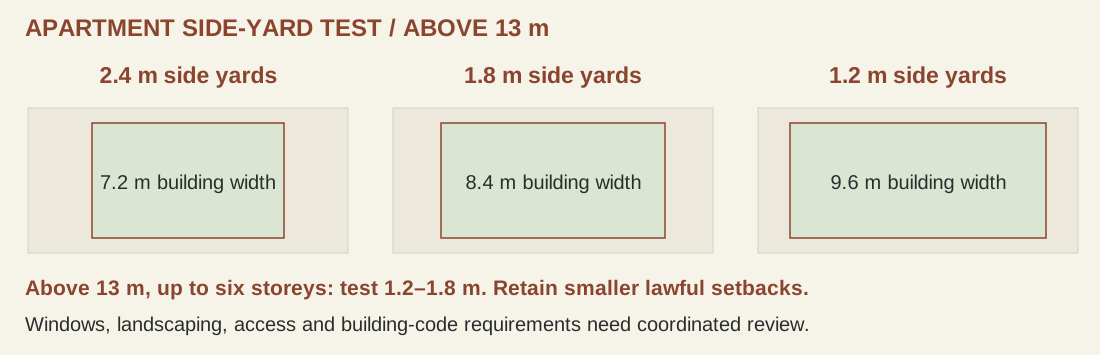
For comparable apartments up to 13 metres, align standards with the general R-zone baseline of 0.9 metres, retaining smaller existing permissions. Above 13 metres and up to six storeys, test 1.2–1.8 metre base side yards. Existing benchmarks have different applications: RM uses 1.2 metres for detached houseplexes and 2.4 metres for apartments; R-zone Major Street rules use 1.8 metres beside walls without primary windows, subject to other conditions. Coordinate windows, the 1.5-metre landscaping strip, access and fire safety. These are proposed changes, not uniform existing permissions.

Apartment visitor parking and bicycle access

Extend the station-area approach of no ordinary visitor-parking minimum to apartments in mapped Transition Zones. Multiplexes already have no ordinary motor-vehicle parking minimum, and resident parking minimums have been removed more broadly. Preserve existing exemptions and applicable accessibility rules. Encourage useful bicycle storage and access for cargo and adapted cycles.

Apartment loading and amenity relief

Direct relief to apartments where obligations actually apply. Multiplexes have no apartment amenity-space quota or residential loading requirement. Residential loading is not required for 0–30 dwellings; the Type G trigger begins at 31. In the Residential Zone category, apartment amenity requirements generally begin at 20 dwellings, with a Major Street exemption through 30. Preserve these exemptions, remove remaining apartment amenity quotas and enable approved shared loading where an obligation would otherwise apply. Also review the separate vehicle-access rule at 25 apartment dwellings, with its Major Street exemption through 60; loading relief does not itself resolve that rule. The City’s wider mid-rise review remains relevant.

Two homes in one rear building

Use a selected transition area to test two dwellings within a building envelope otherwise contemplated for one garden suite. Current provisions refer to one garden suite and a separate single housekeeping unit, so the pilot requires an express permission and supporting standards. It is an incremental policy test before considering broader geographic application.

Illustrative 12 metre frontage: equal side yards of 2.4, 1.8 and 1.2 metres leave building widths of 7.2, 8.4 and 9.6 metres respectively.
A geometric comparison for the proposed test above 13 metres and up to six storeys. Preserve smaller existing permissions. Window, landscape, access and building-code requirements need coordinated review.

Built references / Toronto

Attached homes and rear housing.

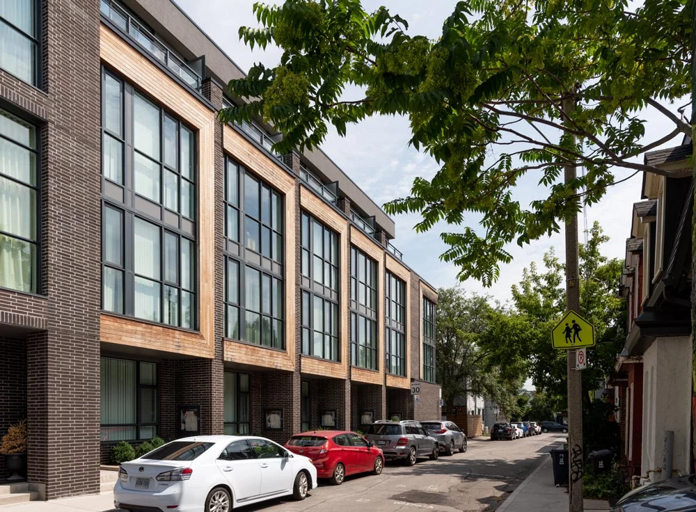
Attached brick and timber-clad homes along Rebecca Street at Motif Lofts and Towns

Motif on Rebecca Street. Attached homes extend the development onto the side street, with separate entrances and nearby house-form buildings.

Image source: RAW Design project gallery.

Ossington Avenue / Rebecca Street

Motif Lofts and Towns

Motif extends a mixed-use Ossington Avenue development along Rebecca Street with attached homes and individual entrances. The side-street photograph shows how that frontage meets the surrounding residential setting.

The side-street homes provide a smaller scale and a repeated rhythm of individual entrances behind the Ossington frontage. The relationship is useful when testing attached housing between a main street and surrounding houses.

The apartments and townhouses were delivered as one development. The example illustrates form and frontage rather than an attached sixplex configuration.

Architecture: RAW Design.

RAW Design / Motif Lofts
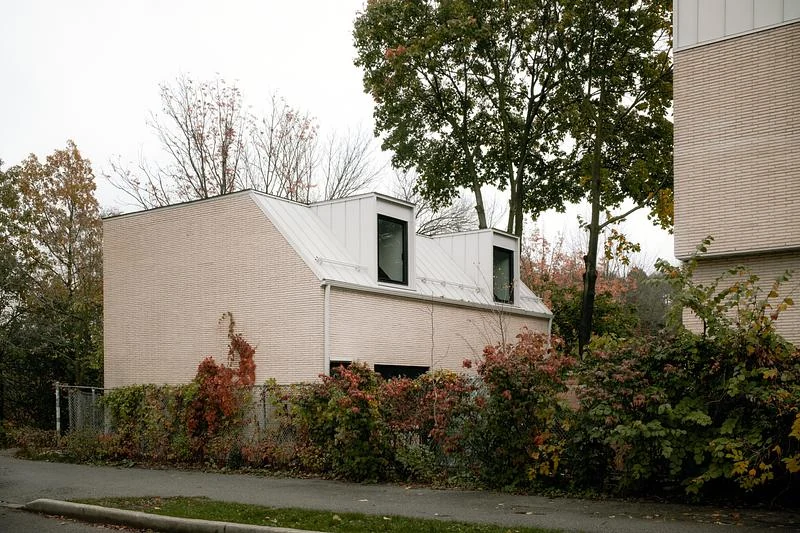
Two brick laneway homes at the Montrose project beside Bickford Park

Montrose laneway homes beside Bickford Park. Rear housing addresses the lane and adjoining open space. The overall project contains six homes, including these two rear homes.

Félix Michaud / Gabriel Fain Architects / v2com.

Montrose Avenue / Bickford Park

Montrose housing

The Montrose project brings street-facing multiplex housing and two laneway homes into one composition beside Bickford Park. Its rear homes address the lane and park, giving the lane a residential role alongside its service function.

The street-facing and rear buildings work as a group, with outdoor space, entrances and the park edge informing the arrangement. The project drawings complement the photograph by showing how the buildings relate across the lot.

There are six homes across the overall project, including two laneway homes. The project illustrates this arrangement rather than the proposed two-dwelling rear-building pilot.

Architecture: Gabriel Fain Architects.

Gabriel Fain Architects / Montrose project and drawings
Compare all eight Toronto references

Block and community services

Share the infrastructure.
Plan the neighbourhood.

Move suitable requirements from individual sites to the block or community. Apartments with a servicing need could share an approved location, while the street and neighbourhood provide other shared functions. This creates no new loading or amenity requirement for multiplexes.

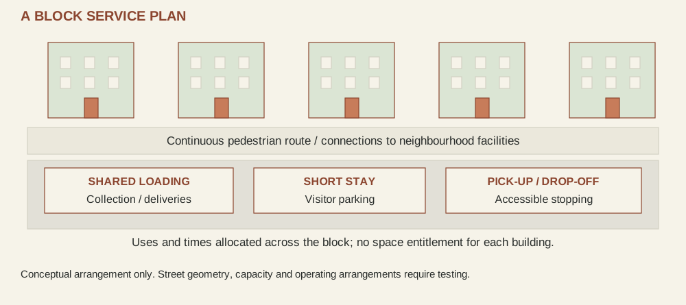
Conceptual block with several buildings using designated shared loading, short-stay visitor parking and pick-up or drop-off areas along the street.
Conceptual service plan. Locations, capacity and time allocations require operational and street-design testing.

Loading and servicing for several buildings

Allow an approved shared location for loading, deliveries and waste collection to serve several buildings. Resolve storage, bin movement, collection schedules, vehicle access and maintenance together. Retain an existing municipal collection route where it works. Any shared arrangement must function before a building relies on it. Do not make a shared plan a new requirement for multiplexes or apartments that need no alternative arrangement. Shared off-street facilities require durable access and operating agreements.

Managed on-street visitor parking

Make the street the principal visitor-parking response. Review parking and stopping restrictions and extend permit parking to suitable areas where it is not available. Distinguish resident permits from visitor and short-stay arrangements, with allocation based on demand and turnover rather than a curb-space entitlement for each development.

Pick-up, drop-off and lay-bys

Coordinate accessible stopping, passenger pick-up, deliveries and lay-bys at block scale. The same space may support different functions at different times. Protect pedestrian routes, cycling, transit and emergency access, and identify the approvals, management and enforcement needed to make the arrangement work.

The neighbourhood is the amenity

Remove remaining mandatory on-site indoor and outdoor amenity-space quotas for eligible apartments up to six storeys. Multiplexes already have no apartment amenity quota; this proposal creates no new obligation for them. Parks, streets, libraries, recreation facilities and community spaces provide the broader amenity. Pair this with safe access, capacity assessment and funded improvements. Voluntary balconies, courtyards and shared rooms can remain part of a project.

Coordinate the service plan with the housing permissions.

Planning, transportation, waste and utility teams should approve the operating arrangements, resources, responsibilities and reporting measures before buildings rely on a shared service. Assign an operator, funding and a fallback if the shared facility is unavailable. Zoning relief alone cannot allocate the curb or create service capacity. This approach draws on The Shape of the Day and Between the House and the Tower, by Blair Scorgie: how changing daily activity and many small developments collectively reshape the street.

Neighbourhood life

Shops, services
and shared resources.

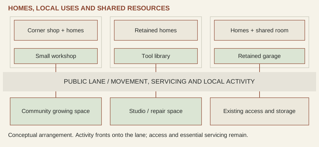
Broaden local-use permissions in approved station areas and mapped Transition Zones. Suitable existing premises should be able to participate without waiting for housing redevelopment.

Build on neighbourhood retail reforms.

Toronto’s Expanding Housing Options in Neighbourhoods (EHON) initiative permits home occupations in ancillary buildings citywide and retail on qualifying neighbourhood-interior lots in the Toronto and East York Community Council Area. Geographic, building-type and operating limits remain. The proposed next step is a wider range of independent commercial and community premises, including operators who do not live on the property.

Current neighbourhood retail and service framework
Conceptual plan connecting homes, a corner shop, small workshop, tool library, community growing space and other premises through a public lane.
Illustrative relationships. Public access, ownership, dimensions and service capacity require confirmation.

Ground floors and neighbourhood corners

Allow small shops, cafés, services, studios and community premises in suitable locations. Revisit use, building-type and floor-area restrictions alongside food preparation and outdoor activity. A café need not always be accessory to a shop.

Independent ancillary premises

Extend appropriate permissions to garages, sheds and buildings designed for laneway or garden suites. Allow independent tenancies and shared occupancy beyond residence-linked home occupations. Adaptation must retain applicable rental protections and workable building access.

Tool libraries, gardens and sharing spaces

Support communal functions as well as private enterprise: tool lending, seed exchanges, community gardens, shared workshops and repair gatherings. Provide clear permissions, affordable access, a steward and practical operating support. Volunteer and non-profit activity need not follow a conventional retail tenancy model.

A secondary neighbourhood network

Where lanes exist and conditions support it, connect active frontages, walking, cycling and local gathering while maintaining servicing. The Mixed-Use Laneways Study informs targeted permissions and operating standards; The Shape of the Day develops the case for shared resources and daily community life. Each lane needs its own access and service assessment.

Proposed next steps, rather than existing permissions. The June 2026 Mixed-Use Laneways Study recommends targeted, low-impact uses calibrated to lane and lot conditions. Clear operating standards and durable access arrangements remain essential.

Built references / Toronto

A lane can be a destination.

Small tables, stools and oak shelving inside Boxcar Social Laneway

Interior of Boxcar Social Laneway. A café provides a place to meet within a rear-lane setting.

Image source: Boxcar Social / Laneway.

Laneway behind 298 Markham Street

Boxcar Social Laneway

Boxcar Social operates a café in the laneway behind 298 Markham Street, near Bathurst and College. It is a small, public-facing destination within a setting usually associated with access and servicing.

A small business can make a rear lane a destination as well as a service route. The connection to the Mixed-Use Laneways Study is practical: suitable premises, independent operators and places to gather need workable access and operating standards.

The selected photograph shows the interior. Lane access, deliveries and effects on nearby homes require a separate assessment.

Boxcar Social / Laneway location
Compare all eight Toronto references

From research to implementation

Make room for
courtyard housing.

Transition Zones could provide a geography for testing parts of the Neptis Foundation’s Impossible Toronto: On the Courtyard research.

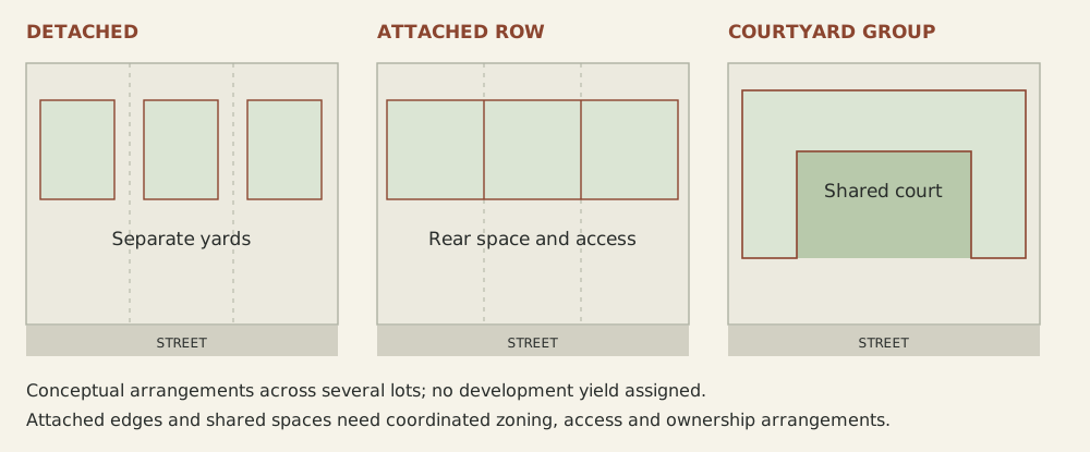
Original conceptual plans comparing detached buildings, an attached row and a courtyard group across several properties.
Original analytical diagram. Arrangements and boundaries are illustrative; no housing yield or shared ownership arrangement is established.

Studio VAARO and Gabriel Fain Architects’ study connects four-to-six-storey housing with attached edges and a shared green centre. Its regulatory matrix examines setbacks, height, density, landscape, servicing and other requirements, alongside building-code and standards changes.

The practical question is how individual projects could contribute to a coherent block arrangement over time. Test a single lot, a pair and a coordinated group, including retained buildings, independent access and servicing, trees, ownership and maintenance.

A shared court needs a durable legal and operating arrangement. Adjacent private yards do not automatically become common space, and an early project needs to function before neighbouring owners participate.

The research is a design proposition, not an adopted Toronto permission. Municipal zoning reforms and provincial building-code dependencies should be identified separately.

Built references / Toronto

Shared space as part of the housing.

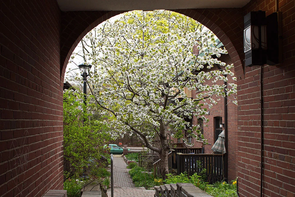
Brick archway opening onto a shared garden and pedestrian path at Bain Apartments Co-op

Bain Apartments Co-op. A pedestrian passage opens into a shared garden, with homes and entrances overlooking the route.

Christopher Berry / Bain Apartments Co-operative.

Riverdale

Bain Apartments Co-op

At Bain, homes face common gardens and pedestrian paths. The space between buildings forms part of everyday life, with entrances and windows overlooking the shared landscape.

The courtyard provides outdoor space and a pedestrian route within the housing group. Its usefulness depends on homes addressing the shared space and on the arrangements for care and access. These relationships inform the courtyard tests proposed here.

Bain combines a longstanding courtyard layout with collective management. New shared courts would need their own ownership, access and maintenance arrangements.

Architecture: Eden Smith and Sons.

Bain photo gallery
Compare all eight Toronto references

A proposed sequence

From selecting areas
to delivering projects.

Each stage should produce a decision or a practical change that advances the next. The sequence below connects the assessment to policy, permissions and delivery.

Policy and regulatory options

Policy, zoning
and delivery.

The initial proposal combined an Urban Structure designation, revised Neighbourhood policies and area-specific zoning. The options below build on that approach and account for subsequent policy changes.

01

Identify suitable areas.

Apply the selection criteria to blocks near main streets, transit and growth areas across the four planning districts. Publish the evidence, boundaries and reasons for exclusions. A first phase can focus on areas where the case is clear and delivery is feasible, with a program for extending the work to other areas.

02

Classify the conditions.

Use transit context and the local assessment to establish the intended forms, uses, intensity and geographic depth of change. Identify the services and infrastructure needed to support it. The classification should explain why the response differs between areas and how it relates to existing permissions.

03

Establish the planned context.

The original option remains available: identify Transition Zones in the Official Plan’s Urban Structure, map them and revise the Neighbourhood policies to support the intended forms and intensity. Other routes include Official Plan amendments introducing secondary-plan changes or site and area specific policies (SASPs), selective land use redesignations, or revised permissions within the Neighbourhoods designation.

See how permissions and investment could support change over time

The appropriate tool depends on the intended outcome and existing policy. Outside existing higher permissions, proposals above four storeys on Neighbourhoods lands require a supporting Official Plan amendment. A SASP is part of that Plan and may be introduced through an amendment. A mapped zoning overlay is implemented through a zoning by-law amendment and must conform with the applicable policy.

04

Test the zoning and design standards together.

Permit the intended forms as of right where appropriate, then test height, density, coverage, setbacks, building length, access and applicable apartment amenity requirements on representative lots. Coordinate those standards with design guidance, trees, servicing, waste collection and the approvals process. Compatible non-residential uses also need an explicit regulatory path.

Compare the proposed standards with the existing baseline using representative lots and groups of properties. Assess net usable area, bedroom mix, accessibility, outdoor space, construction costs and development feasibility. Where greater permissions already apply, retain them. Building-code dependencies and shared-access or maintenance arrangements need their own resolution.

05

Support delivery and review the results.

Use pilot areas and early applications to test the rules, with a commitment to broader implementation. Work with public, non-profit, co-operative and private housing providers, coordinate necessary capital improvements, protect existing renters and address remaining feasibility barriers.

Report on approvals, completed homes, unit sizes, accessibility, tenure, affordability and effects on existing residents. Adjust standards where the evidence shows that they are preventing the intended outcomes.

Allow continued neighbourhood evolution.

A Transition Zone boundary identifies where this program adds opportunities. It should not become a reason to withhold suitable housing elsewhere. Broader housing reforms and any greater applicable permissions continue to matter.

Taking part

Ask Council to
complete the work.

Residents, housing providers and city-building organizations can use the requested action above in a Council submission or planning consultation. Ask for current reporting dates, the resources to meet them and a program that leads to implementation.

Read the documented commitment Discuss the implementation proposal